Project Personnel

Picture of Rafael L. Bras

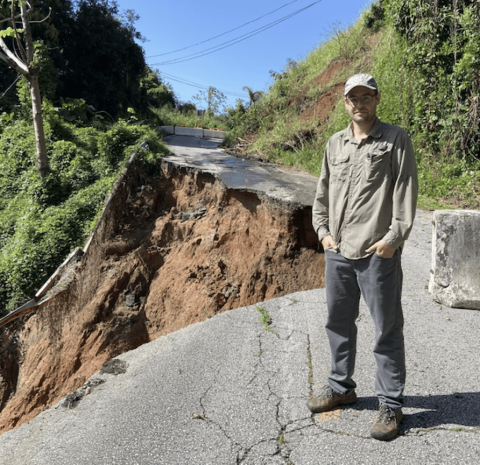
A native of Puerto Rico, Rafael L. Bras is a Professor in the School of Earth and Atmospheric Sciences and the School of Civil and Environmental Engineering at the Georgia Institute of Technology.  He holds the K. Harrison Brown Family Chair. He works in the field of hydrology with particular interest on land-atmosphere-biosphere interactions. Dr. Bras was Provost and Executive Vice President for Academic Affairs at the Georgia Institute of Technology. Prior to becoming provost, Dr. Bras was Distinguished Professor and Dean of the Henry Samueli School of Engineering of the University of California, Irvine (UCI). For 32 years prior to joining UCI, he was a professor in the departments of Civil and Environmental Engineering and Earth, Atmospheric and Planetary Sciences at MIT. He was Chair of the MIT Faculty and head of the Civil and Environmental Engineering department. He has served as advisor to many government and private institutions, including serving in the NASA Advisory Committee, the Secretary of Energy Advisory Board and The Presidential Medal of Science Committee.

Dr. Bras is an elected member of the U.S. National Academy of Engineering, the Academy of Arts and Sciences of Puerto Rico, and is a corresponding member of the Mexican National Academy of Engineering and the Mexican National Academy of Sciences. He also is an elected Fellow of AGU, the American Society of Civil Engineers, the American Meteorological Society, and the American Association for the Advancement of Science. He has received several honorary degrees among many other honors and awards. Dr. Bras has published two textbooks, over 240 refereed journal publications, and several hundred other publications and presentations.  

Roman DiBiase headshot

Roman DiBiase’s research focuses on quantifying the mechanisms of erosion and sediment transport responsible for shaping Earth’s surface and applying this insight to problems ranging from post-wildfire erosion to landscape evolution. He is motivated by the challenge to develop surface process models that satisfy both modern observations and longer-term geologic constraints. Such a mechanistic approach is necessary to better predict landscape response to changing climate and land use conditions, mitigate natural hazards, and understand the dynamic interactions between surface and deep Earth processes. They investigate these problems using fieldwork, topographic and photogrammetric analysis, cosmogenic radionuclides, and modeling.

Alison Duvall headshot

Alison Duvall is a geologist who studies how mountains are built and how the landscape responds to these processes. More specifically, she looks at how plate tectonics, erosion, and climate all work together to shape the Earth’s surface across both space and time. In addition to mountains, she investigates what happens when two blocks of Earth’s crust slide past each other (called strike-slip faulting), changing hill slopes, river channels, and other features of the landscape. Because they are often continuous for long distances, strike-slip faults are especially prone to large earthquakes, but measuring their activity is hard. Duvall hopes to develop new ways of both recognizing and analyzing fault activity directly from surface processes.

K. Stephen Hughes headshot

Dr. Stephen Hughes is a Professor in the Department of Geology at the University of Puerto Rico Mayagüez (UPRM).  He obtained BS (2009) and PhD (2014) degrees in Earth Sciences at the University of North Carolina at Chapel Hill and North Carolina State University.  At UPRM he teaches classes in Structural Geology, Geomorphology, and Field Geology in addition to carrying out research mostly related to tropical landslides and landscape evolution.  His projects have been sponsored by groups like NSF; Puerto Rico Science, Technology, and Research Trust; USGS; USDA NRCS; and NOAA.  He also collaborates in landslide-focused initiatives with colleagues at continental academic institutions and incorporates students into all levels of research and outreach.  One of his important recent publications is the USGS Open File Report “Map Depicting Susceptibility to Landslides Triggered by Intense Rainfall, Puerto Rico.”  Hughes is the PI for the UPRM Storm-induced Landslide Impact Dynamics on Environment and Society in Puerto Rico (SLIDES-PR) initiative. 

erka-istanbulluoglu

Erkan Istanbulluoglu is a Professor of Civil and Environmental Engineering at the University of Washington. He studies the interactions among hydrologic, ecologic, and geomorphic processes in watersheds and how such interactions shape geohazards during climatic extremes. His research group develops and uses numerical models for landscape evolution, ecohydrology,  landslide, debris flow and flood risk. These models are developed to study research questions that span time scales from long-term geomorphic phenomena, such as the evolution of gully networks and mountainous landscapes and their vegetation patterns, to engineering time scale predictions relevant to decision-making and design. His modeling interest also aims to develop models that can be rapidly implemented for near real-time hazard forecasts. 

Karl A. Lang headshot

Dr. Karl Lang is a Geologist and an Assistant Professor in the School of Earth and Atmospheric Sciences at Georgia Tech. His research is focused on the evolution of Earth’s surface of extended geological timescale, using a variety of novel numerical and geochemical tools. He obtained a BS from the College of William and Mary, a PhD from the University of Washington. He was previously an Alexander von Humboldt Postdoctoral Fellow at Karls Eberhard Universität Tübingen, a Vetenskapsrådet Postdoctoral Fellow at Stockholm University, a Visiting Assistant Professor at Pomona College and an Assistant Professor in the City University of New York.

Alesandra C. Morales-Vélez headshot

Dr. Alesandra C. Morales-Vélez is an Associate Professor in the Department of Civil Engineering, Associate Dean of Students and HACU-Liaison at the University of Puerto Rico at Mayaguez (UPRM).  She obtained her BS (2007) and MS (2010) degrees from the same institution and later a PhD in Civil and Environmental Engineering (2014) at the University of Rhode Island. She received the Dwight David Eisenhower Fellowship as an undergraduate (2006), the Department of Energy Fellowship as a graduate student (2008) and the University of Rhode Island Transportation Center Fellowship as a PhD student (2010). She joined the University of Puerto Rico at Mayaguez faculty in March 2015 as a member of the Geotechnical Engineering Group. She is now the Chair of the Geotechnical Engineering Laboratories. In 2018, she served as the UPRM Director of Graduate Studies and Associate Dean of Academic Affairs. Her main research interests are field reconnaissance after extreme events, monitoring soil properties using remote sensing techniques, liquefaction of unique soils such as calcareous sands and non-plastic dilatant silts, short-and-long-term durability properties of crushed limestone aggregate and linking laboratory and field behavior of soils using shear wave velocity. Her first PhD student graduated in 2019. She has volunteered in two earthquake reconnaissance teams (Mexico 2018 and Puerto Rico 2020) and one hurricane reconnaissance team (Hurricanes Irma and María in Puerto Rico 2018). She is a member of ASCE and GEER and co-editor of “Revista Internacional de Desastres Naturales, Accidentes e Infraestructura Civil”.

ScottPeckham

Scott Peckham is a Research Associate at the University of Colorado Boulder in Hydrology, Geomorphology, Modeling, and Cyberinfrastructure. His research interests include physically-based mathematical and numerical modeling, watershed-scale hydrologic systems, source-to-sink sediment transport, scaling analysis, differential geometry, component-based modeling, grid-based computational methods, efficient computer algorithms and fluvial landscape evolution models. Scott has authored numerous, open-source, earth surface process models including a spatially-distributed hydrologic model called TopoFlow and a fluvial landscape evolution model called Erode. He is also CEO and founder of Rivix, LLC which sells a software product for terrain and watershed analysis called RiverTools. Scott has been honored to pursue research as a NASA Global Change Student Fellow (1990-1993) and a National Research Council Research Associate (1995-1998).

mark_piper

Dr. Mark Piper is a Research Associate at the University of Colorado Boulder and a Research Software Engineer at the Community Surface Dynamics Modeling System (CSDMS). He develops open source model coupling cyberinfrastructure for geoscientists, including the Basic Model Interface, the Python Modeling Toolkit, and Landlab. He creates training material and leads workshops for graduate students and early career scientists on best practices in scientific software development.

ramos_carlos

A native of Puerto Rico, Carlos received his Bachelor of Science degree in Geology from the University of Puerto Rico-Mayaguez in 1993. He completed his Ph.D. from the Watershed Sciences program at Colorado State University in 2004. Carlos joined the faculty of the Department of Geography and the Environment and the Lozano Long Institute of Latin American Studies at the University of Texas at Austin in 2013. His areas of research include watershed sciences and applied hydrology and geomorphology. His work has a strong applied component, addressing how human modification of landscapes for the purposes of urbanization, agricultural production, or recreation affects their hydrologic behavior, resulting in accelerated soil erosion, degraded water quality, and impoverished habitats such as coral reefs. He has been principal investigator and collaborator on several NOAA, NASA, NSF, National Park Service, and the National Fish and Wildlife funded projects in the Eastern Caribbean and Latin America, as well as author of journal articles in Scientific Reports, Water Resources Research, The Journal of Geophysical Research, and others. His current work engages with characterizing the magnitude and geomorphic impacts of tropical cyclones in the Caribbean and providing technical assistance to communities suffering from climate change-driven water scarcity problems in Latin America. 

Frances Rivera-Hernández headshot

Dr. Frances Rivera-Hernández runs the PLANETAS group at the Georgia Institute of Technology (Georgia Tech). She is an Assistant Professor in the School of Earth & Atmospheric Sciences at Georgia Tech. Her research is focused on characterizing sedimentary deposits and landforms to interpret present and past planetary surface conditions and habitability. Outside of research, she remains active in several outreach and informal education projects to encourage students from underrepresented communities to pursue STEM careers.

She is a native of Aguas Buenas, Puerto Rico (¡Wepa!) and has been in love with science for as long as she can remember. When she is not sciencing, she enjoys traveling and walking in new cities, learning new languages, cooking, and trying new restaurants.

santamarina_headshot

J. Carlos Santamarina has taught at NYU-Polytechnic, the University of Waterloo, Georgia Tech and King Abdullah University of Science and Technology KAUST. The network of more than two hundred former team members reaches national laboratories, industry, federal and state agencies, and more than 40 universities worldwide. His research focuses on processes involving sediments, fractured rocks and complex fluids through particle-level and pore-scale experiments, combined with analytical solutions and numerical methods. 


ChaopengShen

Chaopeng Shen is an Associate Professor in Civil and Environmental engineering at Pennsylvania State University. His research focuses on advancing fundamental understanding of the interactions between hydrology and other subsystems (e.g., ecosystem, energy and carbon cycles, solid earth and channels). He strives to provide sound physical science, produced by data, data-driven and process-based models, to support decision-making across multiple scales, from catchment to global scales. 

Mehmet Evren Soylu headshot

Dr. Evren Soylu is a Research Engineer II at Georgia Tech working with Bras Hydrology Group. He studies surface and subsurface hydrological processes and their coupled interactions with vegetation dynamics under changing climate, land cover, and human impact. To understand these processes, my research includes designing/using numerical models and field observations. I use field observations to improve understanding of processes, conceptualize models, and corroborate numerical model results. My work focuses on both theoretical and applied aspects of environmental research, with a strong focus on groundwater – land surface processes interactions in the Earth’s critical zone.

meryem-headshot

Meryem Yilmaz Soylu is a research scientist at C21U. Her main research interest is investigating the impact of self-regulation and motivational processes in writing, learning, and video gaming within various media, including online, blended, and face-to-face learning environments. She has worked at higher education institutions and private companies in the United States and Turkey as a faculty member, instructional technologist, social studies coordinator, and project consultant. In addition, she has been serving as an associate editor in Frontiers in Psychology since 2015. She holds a Ph.D. in educational psychology from the University of Nebraska-Lincoln and earned her master's in instructional technology from Hacettepe University.

Monique Tavares headshot
Program & Portfolio Manager, Office of the Executive Vice President for Research, Georgia Tech

Monique D. Tavares serves as Program & Portfolio Manager in the Office of the Executive Vice President for Research (EVPR) at the Georgia Institute of Technology (Georgia Tech). In this role, she manages the implementation of Georgia Tech’s research strategy, Research Next. Mrs. Tavares has been at Georgia Tech for over 20 years in a variety of administrative roles. Half of her Georgia Tech career has been in the EVPR’s Office with responsibility for research administration, financial administration, human resources, and space management. Other Georgia Tech roles included: Director of Global Operations, Project Director, Human Resources Director, and Director of Faculty Career Development Services, the HR arm for instructional faculty at Georgia Tech. Prior to joining Georgia Tech, she lived in Kingston, Jamaica where she worked in advertising, communications, and as an English teacher.

Mrs. Tavares holds an MS in Professional Counseling from Georgia State University and an AB in English and American Literature and Language from Harvard University.

TiltJ_headshot

Dr. Jenna Tilt is an Assistant Professor of Geography Program in the College of Earth, Ocean, and Atmospheric Sciences at Oregon State University.  Her interdisciplinary research utilizes a participatory action research approach to understand and integrate diverse community needs and values with social science and geospatial methods and analyses to identify how communities can equitably build adaptive capacity to anticipate and recover from chronic and acute natural hazards. Her current research projects include: The Cascadia Coastlines and Peoples Hazards Research Hub (NSF); Enabling Interdisciplinary Wildfire Research for Community Resilience (NSF); Co-Creating a Community Resilience Model for Oregon Coastal Hazards (Oregon Sea Grant); and Persist, Adapt, or Transform:  What Drives Wildland-Urban Interface Community Recovery After Wildfires? (BLM, Joint Fire Science Program).

Greg Tucker headshot

Greg Tucker is a Professor of Geological Sciences and a Fellow of the Cooperative Institute for Research in Environmental Sciences (CIRES) at the University of Colorado Boulder. Dr. Tucker’s work focuses on geomorphology and landscape evolution. His research team uses numerical modeling, field observations, in-situ field monitoring, digital elevation data analysis, and other techniques to improve our understanding of processes that shape the earth. His Computational Geomorphology Group also works in designing, developing, and testing software for computer simulation and coupled modeling of earth-surface processes, including hydrology, landsliding, sediment transport, and landscape evolution. The research includes work on present-day geological hazards such as debris flows, floods, and gully network growth, as well as investigation of long-term evolution of landscapes and sedimentary basins. Since 2017, Tucker has served as Executive Director of the Community Surface Dynamics Modeling System (CSDMS: https://csdms.colorado.edu).

Elisa Arnone headshot

Dr. Elisa Arnone is an Associate Professor in the Department Polytechnic of Engineering and Architecture (DPIA) at the University of Udine (Italy), and she is affiliated with the Department of Civil and Environmental Engineering at Georgia Institute of Technology (USA) for Research/Collaboration. In Italy, she teaches Hydrology and Hydraulic Infrastructures. Her research activities focus on physically-based hydrological modeling of rainfall-driven geomorphic processes, root-reinforcement modeling for hydro-geological risk mitigation, and rainfall extremes. She has been collaborating with Bras Hydrology Group for many years on developing physically-based tools to simulate the shallow-landslide hazard across the Luquillo Mountains of Puerto Rico

domenico-capolongo

Domenico Capolongo is an Associate Professor of Physical Geography and Geomorphology at University of Bari (Italy). His research interests are in the field of geomorphology and environmental sciences. He studied the spatial and temporal distribution of erosion processes at different spatial and temporal scales in high rate evolving landscapes. He aims to develop a better quantitative understanding of physical processes operating on the Earth surface. He uses a combination of theoretical, numerical and experimental approaches to understand natural systems, integrating observations and field data (both of active processes and recorded in the geologic record) with theoretical and model results. He uses GIS, remote sensing, and computer simulation as a principal tool for qualitative and quantitative insight into this complex systems and as a virtual laboratory to explore theory by simulation.