Problem
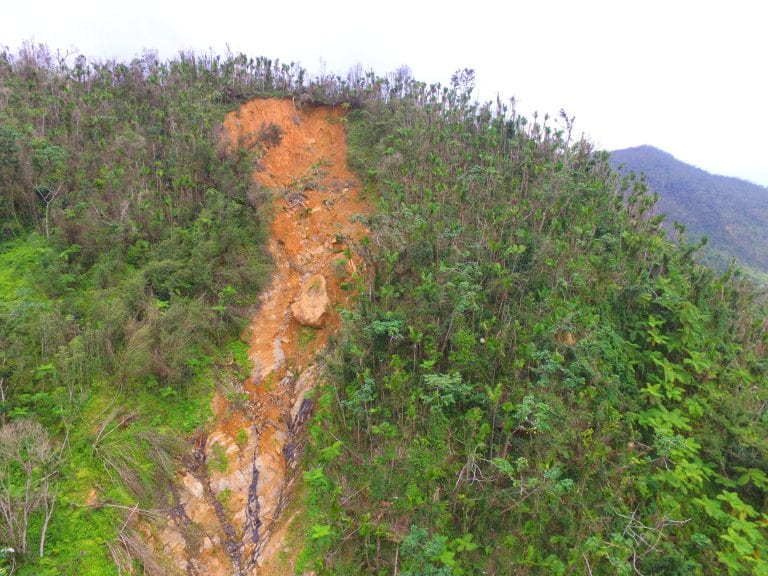
Landslides are a ubiquitous phenomenon in mountainous terrain around the world, and they occur throughout all US states and territories. In the US alone, annual landslide-related losses have been estimated to be in excess of $2B and around 25-50 lives. Worldwide losses are much higher, with an estimated death toll of more than 18,000 lives in the period of 1998-2017.
Both immediate and long term, or cascading, effects of landsliding are important to society and the environment. Apart from the obvious hazard to human well-being and the built environment, sediment transport and deposition, landscape changes resulting in hydrologic and ecological impact, carbon capture or mobilization, and the effect of landslides on chemical weathering are examples of “downstream” impacts of mass wasting that are understudied.
Our center directly address two fundamental questions from the National Academies decadal survey report The Earth in Time: “What are the causes and consequences of topographic change?” and “How can Earth science research reduce the risk and toll of geohazards?” by focusing and mobilizing research in this field and providing an opportunity for core services, field experiments, and community modeling tools.
Mission
The mission of the NSF-funded Collaborative Center for Landslide Geohazards is is to carry out and promote landslide hazard science and community engagement across key landslide-prone areas of the nation, with the following objectives:
Explore the fundamental causes of diverse landslide types and cascading hazards resulting from these phenomena;
Form and Manage a network of integrated regional hubs across key regions of the nation engaged in transformative research, knowledge exchange, and community engagement;
Build and Curate a platform for fieldwork and modeling tools specific to landslide science for the benefit of researchers at-large;
Engage and Partner with communities susceptible to landslides via a structured geohazard preparedness program;
Develop the next generation of diverse science leaders.
These efforts will lead to better predictions and understanding of landsliding and related impacts like sediment transport and deposition, the carbon cycle and landscape evolution, and synergism with the biosphere. The scientific approach will combine existing observations and focused field efforts with advanced modeling of behavior.
Partners


The broader impacts of the Center are multifaceted and collaborative between the seven participating institutions: Georgia Institute of Technology (GT), University of Puerto Rico at Mayagüez (UPRM) University of Colorado Boulder (CUB), Pennsylvania State University (Penn State), University of Washington, Oregon State University, and University of Texas Austin. Through the integral community engagement and education and workforce development activities outlined below, our endeavor will advance the inclusion of historically underrepresented groups in cutting edge science, bridge the gap between landslide science and communities vulnerable to mass wasting, and prepare a new generation of subject matter experts and leaders.
Cohorts of undergraduate, graduate, and postdoctoral students will benefit from mentoring by diverse investigators at participating institutions and partner groups like the USGS, NASA, and others (see attached letters of collaboration). In addition, the development of a much needed, standardized landslide outreach and training “Landslide Ready” program for emergency managers and community leaders will be important to communicate landslide preparedness best practices in a meaningful way.
Collaborators
Organization |
University of Washington Urban Design and Planning |
Universitat Politechnica de Catalyunya |
Universita Degli Studi Di Udine |
NSF RAPID Facility |
University of Washington / CoPES |
Universita Degli Studi Di Udine |
California Department of Forestry and Fire Protection (CALFIRE) |
U.S. Department of Agriculture, Natural Resources Conservation Service Caribbean Area |
Geosetta |
Istanbul Technical University, Civil Engineering |
Ecole Polytechnique Federale de Lausanne |
Oregon Emergency Management |
Washington Sea Grant |
U.S. Geological Survey |
International Institute of Tropical Forestry, U.S. Forest Service, U.S. Department of Agriculture |
Istanbul Technical University, Eurasia Earth Science Institute |
EcoExploratorio Resilience Institute |
Georgia Tech Center for 21st Century Universities (C21U) |
NASA Goddard Space Flight Center |
California Department of Conservation |
NSF Cascadia Region Earthquake Science Center |
Caribbean Climate Adaptation Network (CCAN) |
Washington State Department of Natural Resources (DNR) |
UC San Diego |
Oregon Sea Grant |
Georgia Institute of Technology, Scientific Software Engineering Center |
Office of Govenor Tina Kotek, Oregon |
Natural Hazards Center, University of Colorado |
Consejo Hispano |
CUAHSI |
Oregon Department of Land Conservation and Development |
NWS San Juan Forecast Office |
Cascadia CoPes Hub |
Lincoln County Public Health |
Community Surface Dynamics Modeling Systems (CSDMS) |
International Tsunami Information Center, Caribbean Office |
The Hong Kong University of Science and Technology |
NSF RAPID Facility |
College of Sciences, Georgia Institute of Technology |
Tokio Marine Holdings, Inc. |